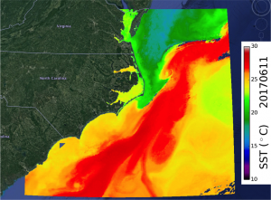
On some water temperature maps that Fathom Science produces, a temperature front is marked. The front is often a place of high fish concentration, because it indicates where cold, nutrient-rich deep water is welling up into the warmer, sunlit regions. At the front, phytoplankton – the base of the fish food chain – get both the nutrients and sunlight they need to grow and multiply. This single-celled salad bar feeds zooplankton, which feed small fish, which feed larger fish. The largest fish are attracted to these regions of more abundant prey – thus fishermen are, too.
The method Fathom Science uses for marking the temperature front on the maps is called Edge Detection. Sophisticated computer algorithms calculate the rate of change of a factor such as temperature over a distance. Where the rate is highest, a front is marked. In other words, the front is the line where warmer water is very close to colder water. This most often occurs when the cold water rises up from the depths, because the deep cold currents hit the continental slope – the edge of the ocean, from the current’s point of view – and are forced upward, or because coastal circulation patterns result in vertical circulation cells. Where the change from areas of warm water to cold water is gradual, it’s not likely caused by upwelling cold water, and thus not likely to be a site of concentrated fish activity. That’s why Fathom Science uses edge detection to mark water temperature fronts on it’s fishing maps.